
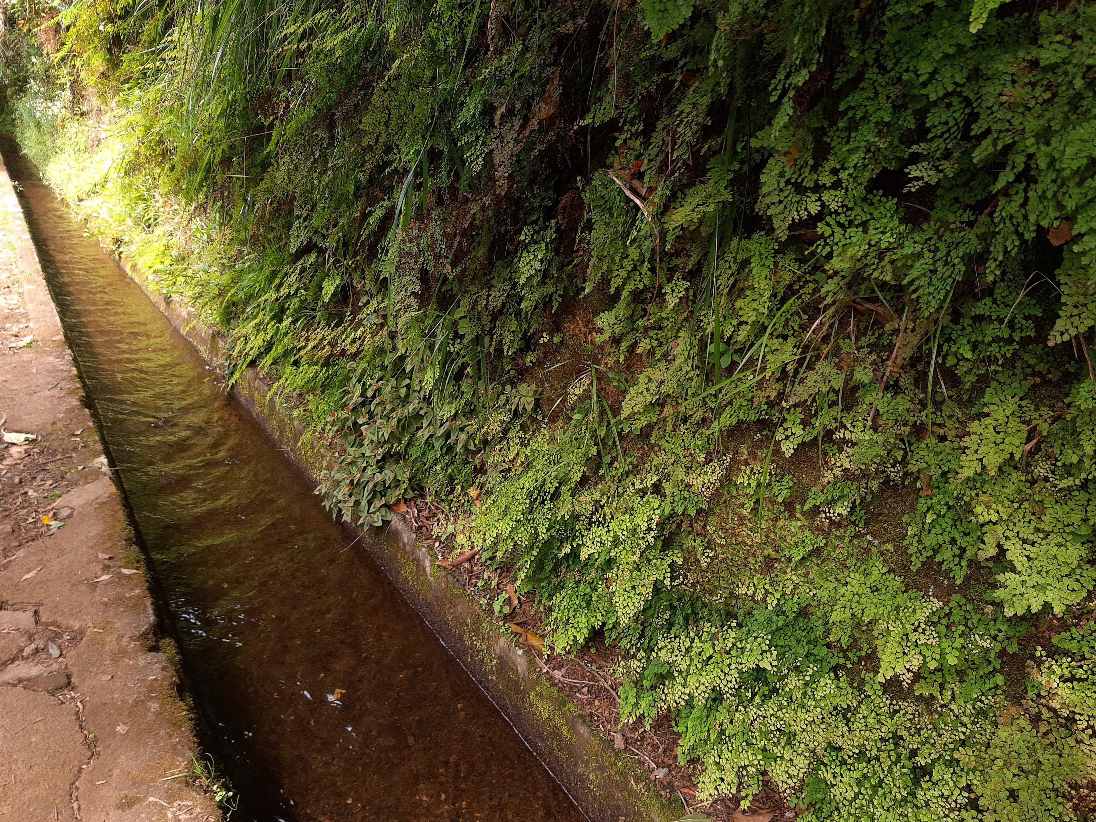
Note only, no attribution required: Levada do Rei, Madeira, PR 10, ferns along, Gerda Arendt, CC0 1.0, Wikimedia Commons https://commons.wikimedia.org/wiki/File:Levada_do_Rei,_Madeira,_PR_10,_ferns_along.jpg
What is a levada? Madeira's water channels explained
Levadas are Madeira's working water channels, not just trails. How they were built, how long the network is, and how to walk beside them without harm.
Most people who come to Madeira call our hikes "levada walks", and that's fair. But a levada isn't a path. It's a water channel, and the path is the narrow ledge built beside it so people could look after the water. When you walk one, you're walking alongside the island's plumbing, and it's still working. Knowing that changes how you walk.
Key facts
- "Levada" comes from the Portuguese verb levar, to carry (UNESCO Tentative List text).
- Counting the small irrigation channels, the network is about 3,100 km long, with about 80 km in tunnels. The main channels add up to about 800 km (UNESCO Tentative List text).
- Levadas still carry water for drinking, farming and electricity today (UNESCO Tentative List text).
- Portugal submitted the levadas to UNESCO's World Heritage Tentative List on 31 January 2017. That makes them a candidate, not a World Heritage Site (UNESCO, ref. 6230).
- The main channels fall by only about 1 metre per kilometre (UNESCO Tentative List text).
Why an island full of water needed channels
Madeira isn't short of water overall. The problem is where it falls. According to the text Portugal sent to UNESCO, the settlers who arrived around 1425 found fertile soil and a mild climate, but the water, though plentiful, was spread very unevenly, by season and by place. Farming on terraces started on the southern side, and later the big projects moved water from the north to the drier south.
So from the first quarter of the 15th century they started cutting channels to bring water from springs and streams to their fields, first for sugar cane and the mills that crushed it. Sugar was Madeira's first big export, and the same text says levada water was essential to the island becoming one of Europe's largest sugar producers and exporters in the second half of the 1400s. Later the channels watered vines, and today they water bananas.
The first levadas were short ditches dug into the soft volcanic rock called tuff. Where the rock was too hard to dig, builders used gutters carved from the wood of native trees, including Madeira laurel (Ocotea foetens) and Canary laurel (Apollonias barbujana), two trees of our laurel forest.
Who built them, and what it cost
For about four centuries, private owners built the levadas: the owners of springs or land, or groups of co-owning farmers called heréus. Each owned a share of the water and paid to maintain the channel, and they elected a committee to run it.
The work was brutal. Workers called rocheiros ("rock men") hung over cliffs in baskets tied to trees or rocks with ropes. With picks, hammers and hoes they cut ledges into the rock face for the channel. The UNESCO text says plainly that many died doing it. Their skill became famous enough that, in the early 1500s, Afonso de Albuquerque, Portugal's governor in India, wrote that the men who "cut the waters through the mountains of Madeira" could divert the Nile. The king never sent them.
In the 19th century, after a crisis in wine farming, the government began paying for levadas itself. The first was the Levada Velha do Rabaçal (the old Rabaçal levada). Work started in 1835 and wasn't finished until 1860. Today the classified trail PR 6.4 carries its name.
The biggest push came after 1947. A state water commission (CAAHM), whose main planner was engineer Manuel Rafael Amaro da Costa, set out to bring water that was lost in the north through the mountains to the dry south. The water dropped about 400 m through hydroelectric turbines on the way, before being sent on to irrigate farms. By 1967, according to the UNESCO text, 400 km of levadas and four hydroelectric plants had been built, almost all the island's farmland (about 20,000 hectares) was irrigated, and the plants produced about 15% of Madeira's electricity at the time. The same text says the long tunnels through the island's central mountains, which carry water from the north to the south, were mostly dug in the second half of the 19th century and in the 1950s and 1960s.
Why the water barely moves
If you've walked PR 6 Levada das 25 Fontes or PR 18 Levada do Rei, you'll have noticed how calmly the water slides along. That's the engineering. The main channels follow the contour of the hills at an almost constant height, with a fall of roughly 1 metre for every kilometre. Gravity alone does the work. It's also why levada walks feel so flat compared with our ridge trails.
A vocabulary that grew up around the water
Many of us grew up hearing words from the levada world that you won't find in a phrasebook. The UNESCO text lists several:
- Levadeiro: the person who controls the water and shares it out between farmers in turns. In the past he worked with an hourglass, a watch or a shell, settled arguments, and carried messages between neighbours on his rounds.
- Giro: the time between one watering of a plot and the next.
- Tornadoiro: the point where water is opened to, or shut off from, a farmer's plot.
- Esplanada: the narrow path beside the channel. It's the part we walk on, and it was built for maintenance and as a right of way for local people.
How to walk beside a working levada
These tips are our own advice as locals, not official rules, but they come from that one fact: the water is still in use.
- Keep the water clean. It ends up in tanks, fields and, for some channels, taps. Don't wash in it, drop food or rubbish in it, or relieve yourself near it. Walk well away from the channel.
- Don't touch the gates or dam the flow. Small sluices and boards control who gets water and when. Moving them, even for a photo, can leave someone's field dry.
- Give way to people working. If you meet someone clearing the channel, they have priority on the ledge. A "bom dia" (good morning) goes a long way.
- Stay on the esplanada. The banks and walls hold the channel up. Climbing on them or cutting corners damages the structure and the plants holding the soil.
- Check before you go. Classified IFCN trails carry a fixed service fee, paid through SIMplifica, the regional government's online services portal (residents and children up to 12 are exempt). As of 31 October 2026, IFCN, the regional forestry and nature conservation institute, lists PR 6, PR 6.4, PR 9 and PR 18 as open (ABERTO). PR 6 runs one way only: out along the Levada das 25 Fontes and back by an alternative path IFCN calls the Bypass. Status changes, so check the official IFCN list on the morning you go.
Next time you're on a levada, listen to the water for a minute. It's been carried along that hillside, by someone's work, for longer than any of us has been alive.
Quick answers
What is a levada? A channel that carries water by gravity across Madeira's hills, with a narrow maintenance path beside it.
How long is the levada network? About 3,100 km including irrigation channels, with about 800 km of main channels, according to the UNESCO Tentative List text.
Are the levadas a UNESCO World Heritage Site? Not yet. They have been on Portugal's Tentative List, the list of candidates, since 2017.
Do I need to pay for a levada walk? The classified IFCN trails carry a fixed service fee, paid through SIMplifica. Residents and children up to 12 are exempt.
Why is the water so slow? The main channels drop only about 1 m per km, so gravity moves the water gently.
Sources
- UNESCO World Heritage Centre, Tentative List entry 'Levadas of Madeira Island' (ref. 6230), text submitted by Portugal on 31 Jan 2017: name from 'levar'; origins in the first quarter of the 15th century for sugar cane and mills; early channels dug in volcanic tuff, with gutters of Madeira laurel (Ocotea foetens) and Canary laurel (Apollonias barbujana) where rock was too hard; heréus co-owners and levada committees; State levadas from the 19th century after the wine crisis; Levada Velha do Rabaçal first publicly financed, begun 1835, finished 1860; CAAHM plan from 1947 led by engineer Manuel Rafael Amaro da Costa, moving northern water south; by 1967, 400 km of levadas and four hydroelectric plants, about 20,000 ha irrigated, about 15% of Madeira's electricity; network about 3,100 km including irrigation channels, about 80 km in tunnels, about 800 km of primary channels; incline about 1/1000; rocheiros working in baskets on ropes, many deaths; Afonso de Albuquerque letter about the Nile; levadeiro, giro, esplanada, tornadoiro; Madeira Nature Park 56,700 ha, about two-thirds of the island; uses today (drinking water, farming, electricity): https://whc.unesco.org/en/tentativelists/6230/ | IFCN classified trails list (PR 6, PR 6.4, PR 9, PR 18 open; distances; checked 31 Oct 2026): https://ifcn.madeira.gov.pt/pt/atividades-de-natureza/percursos-pedestres-recomendados/percursos-pedestres-recomendados.html | Regional tourism directorate (DRT) trail table (classified IFCN trails subject to a fixed fee, except residents and children up to 12; booking via SIMplifica): https://www.madeira.gov.pt/drt/Estrutura/DRT/Informa%c3%a7%c3%b5es-%c3%9ateis-Madeira/ctl/Read/mid/14486/InformacaoId/136342/UnidadeOrganicaId/52/CatalogoId/0