Madeira's new trail rules: what Portaria 595/2026 means for hikers
Portaria 595/2026 sets new rules for Madeira's hiking trails: what makes a trail official, the new signs and boards, and the conduct rules for walkers.
If you've walked in Madeira for as long as we have, you'll know the little yellow-and-red stripes painted on rocks and posts. For years they were our quiet guides on the levadas (the narrow irrigation channels with paths alongside them) and the veredas (old mountain footpaths). This week the regional government published new rules for how those trails are classified, signposted and looked after, and some of it will change what you see on the path.
The short answer: Portaria n.º 595/2026 is Madeira's new rulebook for official hiking trails. It sets what a trail needs to be classified (including a carrying-capacity study), what signs and boards must show (in Portuguese and English, with distance markers at least every 500 m), and the conduct rules for walkers. It was published on 19 October 2026 and took effect the next working day, 20 October. It doesn't change fees or bookings.
Key facts
- What: Portaria n.º 595/2026 (a portaria is a government ordinance), issued by the Regional Secretariat for Tourism, Environment and Culture.
- Published: Jornal Oficial da Região Autónoma da Madeira (JORAM), Madeira's official gazette, I Série n.º 188, 19 October 2026.
- In force: the working day after publication, which makes it 20 October 2026.
- Replaces: Despacho Conjunto n.º 74/2019 of 26 August (a joint order from 2019).
What was approved
The ordinance sets the technical rules for classifying, signposting, using and maintaining hiking trails. As I read it, and as MadInfo also summarised it, the point is one common set of technical rules for every trail, so that letting people walk the paths, levadas and tracks doesn't come at the cost of their safety or of the nature around them.
It sits under the regional trail law from 2022, Decreto Legislativo Regional n.º 24/2022/M, which said the detailed requirements would be set by ordinance. This is that ordinance.
What a trail needs to be "classified"
The trails IFCN (the Institute of Forests and Nature Conservation, which runs most of Madeira's official walks) lists are "classified" routes, the ones with PR numbers like PR 1 or PR 6. Under Article 2 of the ordinance, a trail can only be classified if it:
- is at least one kilometre long,
- is walkable for the terrain (slope, obstacles, surface),
- has a surface of footpath, levada, dirt track or paved path,
- has scenic, natural, geological or historical-cultural interest,
- has foot and road access to its start and/or end, and
- contributes to local socio-economic development.
Whoever proposes a trail (the "promoter", for example IFCN or a town council) has to send a full project: the route, the planned works, the signs, a schedule and a maintenance plan. The technical sheet has to include the distance, approximate duration, highest and lowest altitudes, a 1:25,000 map, a KML file (a digital map file) and georeferenced points of interest. If the land is private, the owners have to authorise both access and maintenance work.
The part we care about most: every application must include a carrying-capacity study, with measures to keep monitoring the impact of visitor numbers and adjust that capacity. In plain words, before a new path is classified, someone has to work out how many walkers it can take without damage, and keep checking.
What you'll see on the trail
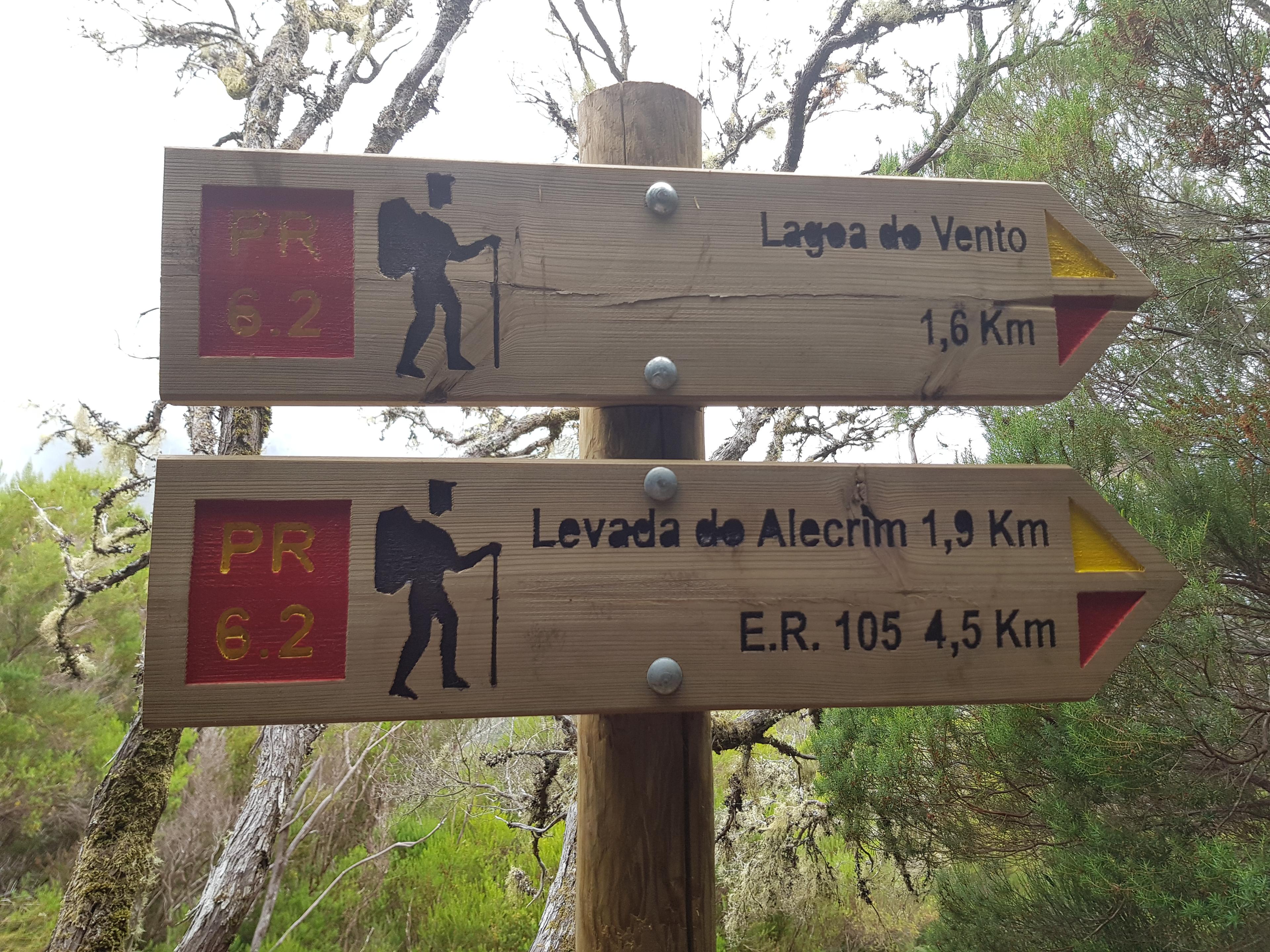
Expect a big board at the start of each classified trail, plus smaller signs pointing the way along it, depending on whether they are a PR (Pequena Rota, a short route) or a GR (Grande Rota, a long route). Every trail on IFCN's current list is a PR, marked in yellow and red.
The boards must show the key details from the technical sheet, rules of conduct and safety, a scale map, an elevation profile, and who looks after the trail and how to contact them. The printed inside panel must be in Portuguese and English. The annexes also set designs for arrows, field marks (including the "wrong way" cross), temporary closure signs, and distance markers no more than 500 metres apart.
For anyone who has stood at a junction in the fog wondering how far it is back to the car, that last one is welcome.
The rules for walkers
Most of this is what good walkers already do, but it's now written down in Article 5. Among other things, walkers should:
- check up-to-date official information, the weather forecast and risk warnings before going,
- check the estimated duration and finish within the set hours,
- tell someone their route whenever possible, and carry a charged phone,
- wear suitable clothes and shoes and bring enough food,
- stick to the marked path, with no shortcuts, and keep a safe distance from cliff edges,
- respect private property and leave cattle gates as they found them,
- not smoke or light fires except in permitted areas,
- not disturb wildlife or feed wild animals, and avoid noise,
- not pick or damage anything in the natural area, and leave no rubbish.
Vehicles are banned except where the law allows them. And when rockfall or anything else cuts the path, the ordinance leaves no doubt: turn around and go back the way you came.
The promoters have duties too (Article 6): clearing vegetation and obstacles, keeping markings and signs in good shape, checking safety structures and risky spots, keeping trail information current and checking regularly that the path is safe and passable. They can be inspected.
Why this matters to us locals
We've watched our favourite paths get busier every year, and we've seen what happens when a landslide closes a trail and people try to scramble around it. A carrying-capacity study for every new trail and clearer closure signs won't fix crowding on their own, but in my view they point the right way: fewer surprises, better information, and paths managed with the forest in mind, not just the footfall.
How to be a good guest on the trail
- Check the official list on the morning you walk. IFCN's classified trails page shows each trail's status: ABERTO (open), ENCERRADO (closed), PARCIALMENTE ABERTO (partly open) or PARCIALMENTE TRANSITÁVEL (partly passable). On the list updated 2 October 2026, several trails were closed or only partly open, so don't trust an old blog post, including this one. Our closed trails page tracks it too.
- Book before you go. Since 1 January 2026, classified trails need an online booking on the SIMplifica portal. The IFCN FAQ lists €4.50 for one trail and €10.50 for the full PR 1. Residents, children aged 12 or under, and people with a disability of 60% or more (with proof) don't pay, but still have to register. See our fees and booking guide.
- Respect a closure sign, even if the path looks fine. In my experience closures usually follow landslides or damage you can't see from the start.
- If the path is blocked, turn back. Don't climb around a rockfall or step off the path into the forest.
- Stay on the marked line. Yellow-and-red stripes mean you're on track; a yellow-and-red cross means wrong way.
- Leave no trace. No fires, no feeding the birds at viewpoints, and carry everything out.
- Tell someone where you're going. Mist comes in fast up high.
FAQ
Does Portaria 595/2026 change trail fees? No. It covers classification, signs and conduct. Fees are set separately (Portaria 801/2025, amended by Portaria 48/2026, according to IFCN).
When did the new rules start? On 20 October 2026, the working day after publication in JORAM.
What should I do if a trail is blocked? Turn back the way you came. The ordinance says exactly that.
The new rules are mostly about what happens behind the scenes. But every board in two languages and every closure sign is only as good as the people who read it. Read them, and the mountains will still be here for the next walker.